|
|
Post by Peter Bakwin on Jan 31, 2010 12:44:56 GMT -5
Jeremy Bradford has the FKT for the High Line Canal Trail at 9h31m14s, set June 7, 2014Marcy Beard has the women's FKT, 14h04m29s, set June 30, 2017Previous: Andy Palmer ran the High Line Canal Trail in 9h35m29s on April 5, 2013Previous: Peter Bakwin ran the High Line Canal Trail in 10h58m on January 29, 2010.This is from the Denver Water website: The High Line Canal, designated as a National Landmark Trail, was completed in 1883 to deliver irrigation water. Today, the canal is owned and operated by Denver Water. The canal trail has become a major recreational amenity in the Denver area, as people enjoy using the canal’s trail for hiking, biking, jogging and horseback riding.The Guide to the High Line Canal Trail is available in hard copy or pdf format. The canal itself runs 71 miles from a diversion dam in Waterton Canyon south of Denver, to the Rocky Mountain Arsenal Lateral in the Green Valley Ranch area in northeast Denver. However, the first 1.7 miles (in Waterton Canyon) and the last 5 miles are not accessible to trail users, so the High Line Canal Trail (HLCT) is 64.3 miles long. As such, it is surely one of the longest suburban recreation trails in the United States. It provides a scenic and extremely indirect tour of Denver's southern, eastern and northeastern suburbs. From Mile 1.7, where the trail starts at Waterton Road, to about Mile 37, the trail is almost all dirt. From Mile 37 to about Mile 50 the trail is mostly asphault, and from Mile 50 to Mile 66 the surface is primarily cement. However, it is almost always possible to run on dirt along side of the paved sections of the trail. The winter of 2009-10 was usually cold and snowy in the Denver metro area, leading to many area trails being either icy or muddy for long periods. Because of this, I started doing a lot of "urban" running, frequently on the well-maintained bike paths around Boulder and in the Boulder-Denver corridor, culminating in two 37-mile runs from Boulder to downtown Denver, mostly on bike paths (with return via public bus). On one of these runs it occurred to me to run the HLCT. While there is excellent and frequent bus service between Denver and Boulder, getting to and from the High Line from Boulder is much harder. On weekday mornings a public bus ( RTD route 63X) runs to the Lockheed-Martin plant, 3/4 mile from the start of the HLCT. It's not exactly convenient, and took me over 2 hours to get from my home to the start of the run. At the other end, there is half-hourly bus service from close to the end of the HLCT to the 40th and Airport Park & Ride, where there is a direct bus back to Boulder -- sometimes. It took me 2.5 hours to get home after running the trail, including a visit to Denver International Airport! Compared to the transportation issues, running the canal was easy. With one exception, the route is obivous -- you just follow the canal. Any questions are quickly cleared up by consulting the Denver Water guide. The tricky bit comes at Mile 8.6 where the canal disappears into a siphon to cross an extensive low-lying wetland area. The work-arounds for this section are long, cumbersome and unaesthetic (private property, busy roads). The obvious choice is to simply cross the wetland, which is of course both really hard and un-ecological -- unless the wetland happens to be frozen, such as on a cold January morning, when the crossing is direct and straightforward. After the wetland and some private property, the trail resumes at Mile 9.8. Resupply stops (mini-marts) are passably frequent along the HLCT. I ran a cool day, and with two 24 oz. bottles needed only 3 resupply stops, at about Mile 22.0, 40.5 and 60.0. All were within 200 yards of the HLCT. This is a surprisingly good route! Up to about Mile 50 it is especially nice -- rural, peaceful, lined with cottonwoods, and with frequent big views of the city and the Front Range of the Rocky Mountains to the west. After 50 it becomes a little more "urban" feeling, though part of that is probably the cement. Besides being tough on the legs, running on cement just feels more urban because you get the impression you are on a sidewalk. Around Denver, everyone has run or biked on the HLCT, but I have never heard of anyone running the whole thing. While 64 miles is definitely long, the trail is basically flat, the surface is good, and resupply is easy, so this is a good winter project -- especially if you can get someone to drop you off and pick you up! Andy Palmer crushed my time on April 5, 2013, running the whole HLCT in 9h35m29s. His report is posted below. Jeremy Bradford made 3 unsuccessful attempts at Palmer's time, before finally taking the FKT by just 4 minutes on June 7, 2014, 9h31m14s. Bradford ran an additional 1.5 miles to avoid private property in the area around Mile 9 where the canal trail disappears. His report is also posted below. Marcy Beard set the first known women's time for the Trail, 14h4m29s on June 30, 2017, as reported below. The people who built the High Line Canal more than a century ago didn't envision that people would be using their ambitious project as a recreational outlet in the midst of a busy urban area. In fact, to the builders of the 71-mile High Line, the canal was solely a commercial scheme to bring South Platte River water to settlers for drinking and farmers for agricultural purposes following a gold rush in 1859 near the confluence of the South Platte and Cherry Creek. -- From the Denver Water "Guide to the High Line Canal Trail" 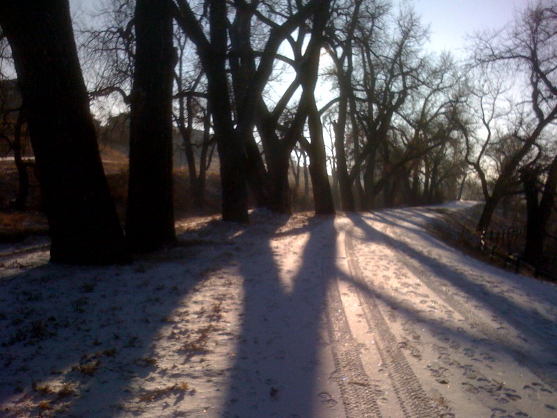 High Line Canal Trail in Littleton 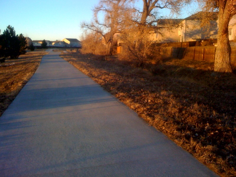 At its northeastern end, in Green Valley Ranch, the canal is little more than a furrow next to a neighborhood bike path. 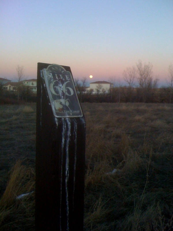 Mile markers aid navigation. This is the last one.
|
|
|
|
Post by Aaron Kennard on Jan 31, 2010 14:47:44 GMT -5
That is cool, thanks for sharing that report. And nice job! That does sound like a fun winter run to do in denver. I was thinking about the cherry creek trail, but its cement the whole way. the HLCT sounds much better.
|
|
|
|
Post by Peter Bakwin on Apr 16, 2013 11:24:41 GMT -5
Here is Andy Palmer's report on this FKT run of 9h35m29s on April 5, 2013: High Line Canal Run April 5th 2013 Andy Palmer I have run countless miles on the High Line Canal Trail (HLCT) as it has been only about a mile from the two places I have lived in Colorado. It's great for a fast flat run and all three of my girls have covered many miles of the trail in the jogging stroller. For years I had thought about riding my bike to work via the trail, but still haven't accomplished that. The thought of running the entire length never crossed my mind until I came across Sherpa John's 100K report of his 2012 run and Peter Bakwin's report of his 2010 FKT run (above). After reading those the seed was planted. I'm running the 100k C.U.R.E. on April 20th a figured running the HLCT would be a good pacing experiment as well as a chance at setting a new FKT. I'm well aware that running 100k+ two weeks out from a race doesn't make for a very good taper, but I've always hated the concept of tapering. It gets in the way of training (i.e. running for fun). The above reports give a good description of the trail so I won't go into too much detail about that. As Peter notes a self-supported run of the trail can be a logistical headache, unless you happen to live near one end and work near the other. I was going to treat this run as a really long commute. I work at Buckley AFB, about 7 miles from the trail's end and had considered having someone from work pick me up, but my co-workers already think I'm crazy enough (including those that have finished the Leadville 100). To keep in the vein of self-supported from home to work I instead drove out to the end of the trail on the day before and locked up a bicycle in the bushes. Then on my bike ride home I stashed various bottles of Perpetuem, Heed, Gatorade and water at miles 60,53,42,30 and 23. After a 1:15AM alarm and mandatory coffee I was out of my house in Highlands Ranch by 1:30 and hopped in the car for the 8 mile drive to the trailhead (with two additional bottle drops at miles 10 and 17). The parking area at the trailhead on Waterton road was closed for construction so I parked in the Roxbourough shopping center about a mile away. During the short jog to the start I back tracked on HLCT for a few hundred yards discovering a section was closed off for the construction project. This brings up a dilemma myself and many others undoubtedly have come across while attempting an FKT run. What is the proper way to handle trail closures, detours and short jaunts across private property? Imagine being hours/miles into a run only to discover an unplanned trail closure. No one wants to have their efforts voided by trail conditions out of their control but it's also important to adhere to the rules of the trail. For now common sense will have to prevail and as small as the FKT community is I doubt it will be much of a problem. Only when there is a deluge of people making FKT attempts on the HLCT on a daily basis do I see this being an issue. A couple of fence hoppings found me back on Waterton road and at 2:10AM with my foot on the white line I started the clock. My plan was to run 8:30 miles for as long as possible. This seemed reasonable as two weeks earlier I ran 40 miles (much of it on the HLCT) in just under 8 minute pace. Still being relatively new to ultra running I always find it difficult to run as slow as I need to from the start. Between the excitement of finally running and the slight tailwind today was no different as the first two miles were covered in about ~8:00. I discovered that if turned off my light that helped slow me down a bit. The primary users on this first section of trail seem to be horses so the trail was a bit choppy and sandy but not a problem with fresh legs. After a bit I settled into something resembling my intended pace. The first and biggest trail issue comes in crossing Plum Creek at mile ~8. The options are a mile+ detour on Titan and Santa Fe roads or foraging across the creek. This section is only a few miles from my house so on a recon run I plotted an intended course across that involved running down a farm road to the right, running up the banks of the creek for about 200 yards, then across the creek up a hill and back on the trail. This meant getting wet feet but the 100k C.U.R.E. has something like 20 creek crossings so I better get used to running in wet feet. On this route there are a couple of signs that say no bicycles but no fences to hop so I could justify it as not trespassing. Tracking the route in the dark with a weak bike light is a bit different then broad daylight so I ended up getting wetter and had a bit more bushwhacking then I intended, but after only a few minutes I was back on the trail. I quick check of the Garmin showed I was 1:06 into the run and still on pace @ 8:28. I few minutes later showed I was still @8:28 and still at 1:06!!! The stop button had gotten bumped while bushwhacking; I was a bit bummed that I wouldn’t have a perfect GPS track, but had only lost about .3 miles or so. The trail at this point was a farm road that joined the proper canal trail at about mile 10 where my first bottle of Gatorade awaited. The next 20+ miles of the trail I have ran dozens of times and just focused on maintaining pace and enjoying the experience. At mile 23 I passed the sight of my worst ever running injury; rolled my ankle badly on a piece of cottonwood bark in 2002. Why is it always the simple things that wreak the most havoc? Not long after that I encountered my first person on the trail (it was only just a bit after 5AM), there was very little traffic on the trail today. Here is where the trail gets quite loopy and you run what seems like 10 miles for every two as the crow flies. Crossing Belleview at mile 32 I had stashed my big bottle of Perpetuem and was happy to find it cold and palatable, Perpetuem is not something you want to drink warm and had held up well from the day before. At this point I was starting to fatigue a bit and my pace dipped into the 8:40 range for the next 10 miles. The only real trail detour occurs around Wellshire golf course at mile 36.0. This is a detour you want to follow and there a good signs leading the way. I’ve played golf there and know there is no trail along the canal to follow anyway. Even though the trail is paved along this section there are almost always good dirt side trails, this is true for pretty much all paved sections the length of the HLCT. Sunrise had occurred about an hour before but it would fortunately stay behind the clouds for almost the entire run. The temps were ideal and still in the mid 40’s. Miles 40-55 were the only real tough mental sections… Why am I out here? This is madness!! Trying to figure out if I’d drank too much? Not enough? The longest distance I’d ever run was last year’s Leadville Silver Rush (47 miles) and I was way past that. My pace was now in the 9:00 range and I smartly switched my GPS to a screen that I couldn’t tell how fast (slow) I was going. Knowing I was well ahead of the FKT pace helped push me on. Heed Gatorade and a fresh shirt at mile 44 and another big bottle of Perpetuem at 54 were much needed. By the time I crossed 6TH ave. at mile 56 I knew I was going to make it and a tiny bit of euphoria set in. Euphoric or not I still had ~10 miles to go and tried to find a pace that wasn’t going to leave me wrecked for days to come. Convincing yourself you could run faster if you had to is a good mental trick but in reality it was probably a big lie J. Any faster would probably have led to a complete meltdown. Some trail meandering around Colfax Ave. lead me to my last Gatorade/water drop at mile 60. The next section is a bit tricky but as it only a mile or so from work I had run it several times. The canal trail disappears near Spinghill golf course and Sand creek. It is easy to follow the trail off to the south but this is not High Line canal, even though some maps label it that way. Instead I veered to the left off the main looking trail and ran up Sand Creek a ways (fortunately it’s aptly named; all sand no water) and up an embankment. After running across Colfax and then Tower the trail proper begins again at about mile 61. The next few miles are the least maintained along the entire trail but have a nice soft surface. Just watch out for that cottonwood bark!! The last trail conundrum is crossing I-70, unless you’re a trail purist I would recommend taking the Tower/32nd bypass. For this run I was following the canal and running under I-70… There is no trail, just a trash filled low clearance drainage ditch. I had to be careful not to bang my head on the steel cross beams. I wasn’t careful enough and rung my bell pretty good on the last two. That actually cleared my head a bit for the final 3 miles. The final stretch through Green Valley Ranch would be really tough if the end wasn’t so close. It’s a paved trail which is great for the local residents but not If you’ve just ran 62+ miles. I run on pavement more often than not but at this point it hurt!! Instead I ran in the uneven grass/weeds along the trail. Before I knew it I has passed mile marker 66 and was on Piccadilly Road at 11:45AM. It was over…. No finish line, no crowds, just the blissful feeling of completing a good run. The most difficult task of the day was pushing my bike up from out of its hiding place, not fun on tired wobbly legs. A short ride to Buckley, a shower, and I was at my desk by 12:45 where I pretended to be working for the next few hours. The last piece of the run was taken care of later that night when my wife and I drove out to Roxbourough to collect my car, which was fortunately still there. Run totals: Total Elapsed Time 9H35M29S Time stopped for bottle retrieving, clothing adjustments and nature calls: about 4min Garmin Mileage 64.8 (+ about .3 miles for the time watch was bumped) Total mileage via mile markers ~64.4 Average pace: 8:48/mile Strava Activity Report |
|
|
|
Post by Peter Bakwin on Jun 14, 2014 15:47:06 GMT -5
Here's Jeremy Bradford's report on his FKT run of 9h31m14s, set June 7, 2014.Having spent most of my life living in Aurora and Denver, I've been playing on parts of the High Line Canal Trail since I was a kid. Right now I live about two miles away from mile marker 42. Earlier this year, while out running with a friend, I learned that there was an established FKT for the whole trail and I became intrigued. Researching the FKT, I learned that it was held by Andy Palmer, whom I had never met in person, but was familiar with due to all the Strava CRs he's set around town. When I saw that Sherpa John was hosting a Fat Ass run on the first 100k of the trail in March, I figured I’d join the group and take a shot (albeit a long shot) at existing record. I found the link to Andy Palmer’s FKT on Strava and started communicating with him about the trickier parts of the course. Displaying great sportsmanship, he generously offered to meet me on the run and guide me through the route he used for crossing Plum Creek. Glad he did, because it’s some serious bushwhacking to find your way through that section. Long story short, I ended up finishing the full length of the trail that day, but not at record pace. In fact, I missed it by over a full hour. Basically I fell apart around mile 40 and then just slogged my way to the end. I had a 100 mile race the following weekend and figured that even slogging can be good training (turns out that might not have been such a great move since I ended up with a minor Achilles injury that was problematic for the next few weeks. But I really just wanted to establish a baseline on which I could improve. Seems like persistence is everything in this sport. In the following months, when I had a free weekend, I went and stashed drinks along the trail and made two more unsuccessful attempts. The first one I went too fast and burnt out around mile 30. The next one, just the weekend before the last successful attempt, I paced better, but around mile 42 decided that I didn't have it in me to hold that pace for another 20+ miles. And on this last successful attempt, I think I got it just right and ran a pretty steady pace throughout. Since I didn't leave myself much wiggle room, the last ten miles or so were a little more frantic than I would have liked. Kind of hoped to bank some time and then just cruise it in at a comfortable pace. But as it turned out, I had to keep pushing hard right up until the end, besting the former FKT by only 4 minutes. I should also note that this fourth attempt was about 1.5 miles longer than the prior existing FKT. This is because I was unable to cross through the private property at Plum Creek (around mile 9) and was forced to take the road detour. On my attempt the weekend beforehand, I was seen crossing the creek and was chased down by a three-wheeler riding landowner who scolded me for cutting through his property. Since I could only get away with playing dumb once, I took the trail detour on Titan Rd. and Santa Fe for this last run. Due to the extra distance the detour adds, I had to increase my pace by about 13 seconds per mile to contend for the FKT. I ended up averaging an 8:35/mile, which allowed me the FKT by a mere 4 minutes. The whole undertaking turned out to be an incredible challenge and was great training for my summer ultra season. I’m fortunate that the trail is so near my home and afforded me the opportunity to make repeated attempts. Unlike being in a race, I was able to really assess my fitness and hone my strategy with repeated attempts. And unlike a training run, I was motivated to push myself hard and far as if I were racing. But probably best of all, it was free. Other than the few bucks I spent on sport drinks, which I stashed along the trail, it didn't cost a thing to keep trying. And although I’ll be glad not to see the High Line Trail again for some time, I can see myself returning to this challenge come fall or winter. Can’t help but think I might have left a few minutes out there. Here’s a link to the Strava file for the successful run (6/7/14 - 9:31:14): www.strava.com/activities/150768801Run totals: Total Elapsed Time 9H31M14S Garmin Mileage 66.6 (Including extended road detour) Average pace: 8:35/mile And here are links to my first three failed attempts: 1st: (full course - 10:39:39) (3/15/14): www.strava.com/activities/1209644202nd: (aborted at mile 29.2) (4/24/14): www.strava.com/activities/1338554383rd: (aborted at mile 42.7) (5/31/14): www.strava.com/activities/147923222Jeremy Bradford
|
|
|
|
Post by marcybeard on Jun 29, 2017 8:49:16 GMT -5
Tomorrow (Friday June 30) I'm planning to attempt to run the High Line Canal Trail from south to north to set the first female FKT. Tracking link: share.garmin.com/MarcyBeardIt will be a supported run, planning to start around 5 am. If anyone is interested in running (and walking) parts of it, feel free to find me and join in. Hopefully I picked a day that won't be quite as hot as it has been lately. |
|
|
|
Post by marcybeard on Jul 1, 2017 9:40:19 GMT -5
FKT run (first female time) complete! I finished yesterday in a total time of 14:04:29, supported by my husband at various points and a friend who ran 10 miles with me. It was a remarkably cool summer day in Denver, although later in the day (maybe 80 degrees) was a bit rough. Nice trail! I ran a large % on dirt/gravel/grass and didn't have to pound too much pavement over the course of 66 miles. Challenging for the miles and miles of flatness. Lovely neighborhoods, wide path, friendly runners and cyclists, all in all an excellent day. GPX track and a couple photos attached. Here's an updated link to the trail guide and map: www.denverwater.org/recreation/high-line-canal/guide-to-the-high-line-canal-trailI didn't find this until the night before, but it would have been nice to read through in advance. Better yet, someone should develop an app that knows where I am and reads each section to me as I reach that mile marker  The trail was mostly easy to follow, with a couple questionable spots that I'll detail in my report. I had pre-scouted from mile 60 to the end and was really glad I did. Some notes: - It appears that the first 1.7 miles might now be accessible? I didn't see this option until reading the guide later. It was dark when I started and I didn't check the south side of Waterton Rd. I started in the same place as all previous FKT runs, at Waterton Road. - I ran the Titan Rd. detour at mile 8.6, same as Jeremy's successful run. - There are "no trespassing" signs on the gate that gets you out to Titan Rd; also some road construction on Titan to make things interesting. - At mile 36 there is signage directing trail users to the right, along Jefferson out to Colorado. This would be the best way to go, I think. I went north to Hampden like others have done, but there is no sidewalk on Hampden. Using Jefferson is the same distance and would be a nicer route. - At mile 63.8 there are "no trespassing" signs on gates at either ends of the field crossing between 38th and 40th streets. Full report to follow. |
|
|
|
Post by marcybeard on Sept 8, 2017 17:26:49 GMT -5
|
|


 The trail was mostly easy to follow, with a couple questionable spots that I'll detail in my report. I had pre-scouted from mile 60 to the end and was really glad I did.
