Post by Peter Bakwin on Aug 10, 2010 21:42:26 GMT -5
Leor Pantilat has the FKT, 15h46m, from Whitney Portal to Crescent Meadow, including the summit of Mt Whitney, September 2, 2012.
Before that, Brett Maune ran 18h39m, September 2, 2011.
The previous FKT was Brian Robinson & Peter Bakwin, 24h58m August 19, 2010.
Marcia Rasmussen ran the HST in 30h from Whitney Portal to Crescent Meadow, but not including the summit of Mt Whitney, September 2-3, 2007.
Sarah Thompson has the women's FKT of 23h05m from Whitney Portal to Crescent Meadow & without summitting Whitney, July 10, 2016.
Allen Currano did the HST yo-yo (Crescent Meadow to Mt Whitney & back) in 44h02m, August 13-15, 2016.
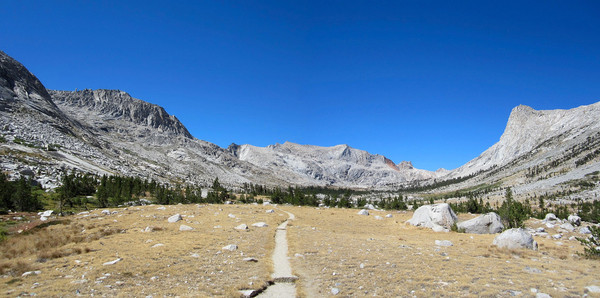
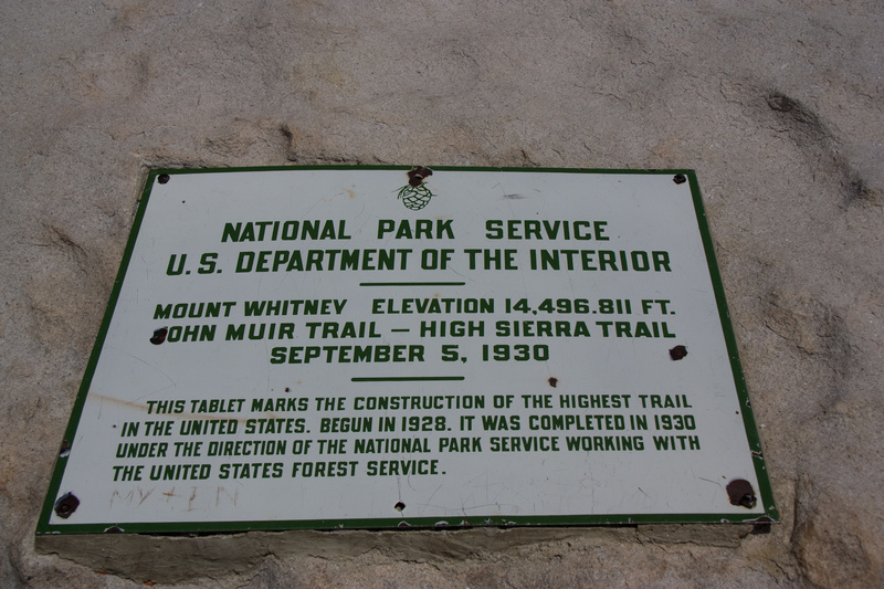
The High Sierra Trail runs 49 miles from Crescent Meadow in the Giant Forest area of Sequoia & Kings Canyon National Park to a trail junction with the John Muir Trail at Wallace Creek. From there the HST & JMT are the same trail to the summit of Mt Whitney. Hikers must continue another 11 miles from the summit to reach the trail head at Whitney Portal. So, as a practical matter, the HST is really 72 miles from Crescent Meadow to Whitney Portal. Reading most descriptions of the HST one gets the impression that it technically includes only the 49-mile section west of the JMT. However, the Mt Whitney summit plaque (below) suggests that the HST reaches the summit. Still, there are questions about the eastern endpoint of the trail, as discussed by Marcia Rasmussen below. It seems most complete to consider the HST as running from TH-to-TH (Whitney Portal to Crescent Meadow), and including the summit of Mt Whitney. But, people should just be clear about what they have done, and provide intermediate splits so that times can be compared.
Most hikers travel in the HST in the west-to-east direction, which allows some time for acclimation to the higher terrain to the east. However, the higher altitude of Whitney Portal (8360') vs. Crescent Meadow (6700') argues for speed attempts to be done east-to-west. This is especially true since Mt Whitney, just 11 miles from Whitney Portal, is at an altitude of 14,500 feet, providing for a net loss of nearly 8000 feet from this point to Crescent Meadow. The permit process (below) also makes east-to-west trips more practical.
A note on permits: To do the HST in one push (without camping) one requires only a day-use permit for Mt Whitney. This page describes the procedure for obtaining permits. Basically, you can enter the lottery in February (by mail), or you can show up by 2PM the day before your hike at the Interagency Visitor Center in Lone Pine and try for (by another lottery) a walk-in permit. Walk-in permits are normally available, but definitely not guaranteed. Even if you have a permit reservation from the February lottery you must still pick it up at the Interagency Visitor Center in Lone Pine the day before your trip.
Despite the quality of the route & long history of this trail, speed trips on the HST are rare. Perhaps the 300-mile, 5.5-hour car shuttle for a 72 mile run has something to do with this! Also, the HST is a VERY committing route. Once you drop down off the west side of Whitney the bail outs are extremely long and will deposit you at remote trail heads a LONG way from your car.
At 6:00AM on 2 September 2007 Marcia Rasmussen set out to run the HST in a single push, starting at Whitney Portal. Marcia skipped the 4.8 mile out-and-back from Trail Crest to the summit of Mt Whitney, so technically she did not run the entire HST. She arrived at Crescent Meadow exactly 30 hours later. Her detailed report is below, and speaks beautifully of the love of the mountains that serves as the foundation for many speed trips.
Sarah Thompson reports below running the HST from west to east in 23h05m on July 10, 2016. Like Rasmussen, Thompson did not summit Whitney.
"Long-distance running is really, really, REALLY boring. I honestly had no idea until I ran 70 miles through some of the most beautiful terrain." - Sarah Thompson
The first speed run of the entire HST (including Whitney) of which we are aware was done by Brian Robinson and Peter Bakwin, starting at Whitney Portal at 4:45AM on 19 August 2010. Splits from their 24h58m trip are below. Robinson was unable to train at altitude and had difficulty on Whitney, which cost a lot of energy and left him calorically depleted. The pair soldiered on, but took a wrong turn at around 2AM just 6 miles from Crescent Meadow, adding about 2 hours to their trip. They recorded splits as follows:
Whitney Portal 0h00m
Trail Crest 3h01m
Mt Whitney 3h57m
Trail Crest 4h46m
Wallace Creek (JMT junction) 7h40m
Lower Kern Canyon 10h50m
Kaweah Gap 16h19m
Bearpaw Meadow 19h24m
Crescent Meadow 24h58m
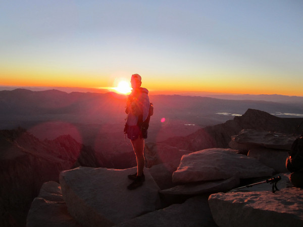
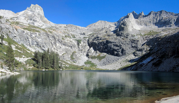
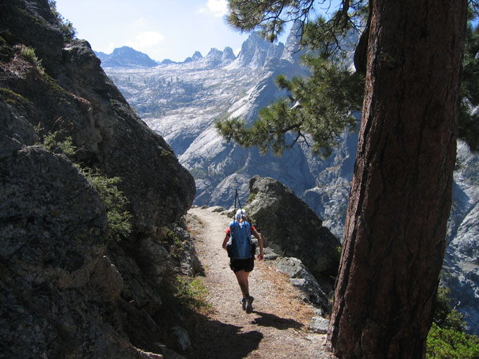
Subsequently, Brett Maune lowered the FKT to 18h39m on Sept. 2, 2011, as reported below. One year later, Leor Pantilat recorded an excellent 15h46m, as reported below, along with Pantilat's usual stunning photos!
Allen Currano reports below doing an HST yo-yo from Crescent Meadow to Whitney and back in 44h02m, August 13-15, 2016. Currano started at Crescent Meadow and reached the summit of Whitney in 20h06m, which appears to be the eastbound FKT for the HST. He spent 20m on the summit, then returned to Crescent Meadow in 23h36m.
Big Terrain on the HST
Here's Marcia's detailed report from the ULTRA List archives:
Sunday of Labor Day weekend is a busy day for the Mt. Whitney Trail. I am shocked to see numerous used poop bags left alongside the trail, as if it were garbage collection day on the mountain. When I stop at Trail Camp to refill my water bottle, the water source there is polluted with chunks of someone's discarded pasta. So, after completing the ninety-some switchbacks shoulder to shoulder with the hordes, I am pleased NOT to accompany them all to the summit. When I turn off alone onto the High Sierra Trail, someone calls out to me that I have made a wrong turn. I grin. In this case, it was most definitely NOT a wrong turn.
I leave Whitney Portal at 6:00 AM with the intention of running the 71-mile High Sierra Trail nonstop. At Sandy Meadow, somewhere around mile 16, I meet a gentleman hefting a large backpack, with a clean white tea towel folded and hung carefully from his chest strap. "Where are you headed?" he asks.
"Giant Forest." I try to sound casual.
"You've got a long way to go." The gentleman appears to think about this a little more. "You've got a REALLY long way to go," he said again, eyeing my tiny day pack curiously. "When do you plan to get there?"
"Tomorrow afternoon." And then, to add a little more credibility, I add, "I run a little."
Another pause.
"Why would you want to do that?" From his expression, I can see that this is a real question. He genuinely wants to know why someone would run quickly through this beautiful country, rather than taking time to savor every step.
I nod. "Well, I've done it the slow way too. Sometimes it's nice to get rid of the heavy backpack. It's a feeling of lightness and freedom, to glide along almost effortlessly though the high country." I explain that if I go nonstop, I'm spared the weight of sleeping gear and a heavy food-storage canister to protect my food from bears while I sleep.
The gentleman appears thoughtful. He looks at my tiny runner's pack, looks at his own heavily-loaded backpack, and looks up at the trail ahead of him, as it switchbacks endlessly up the back side of Mt. Whitney. He nods quietly. I think, for the first time, he understands the beauty of trail running.
"I've got to be going. Have a nice time on Mt. Whitney." I turn and pad across Sandy Meadow. A soft breeze ripples through my hair, and I suddenly feel I haven't a care in the world.
The gentleman turns and starts up the trail in the other direction. It may be my imagination, but I think I hear a soft sigh escape his lips.
Afternoon approaches, and dark clouds begin to gather over the high peaks. I reach Wallace Creek, where the High Sierra Trail and the John Muir trail diverge. I follow the High Sierra Trail along Wallace Creek as it dives sharply downhill, though a rocky canyon. The creek bubbles and gurgles and cascades noisily toward the Kern River canyon below. Again, I feel the breeze in my hair, but this time it is cooler, and it accompanied by the rumbling of thunder. It's time to get off the ridge. I pick up my pace slightly, hoping to reach the relative safety of the Kern Canyon before the storm breaks.
The upper Kern Canyon is a jungle of bright green Manzanita brush, with twisted red trunks-a bright contrast to the white granite walls of the canyon. Occasional thickets of aspen rustle in the breeze of the oncoming storm. The wind carries a shower of aspen leaves, just barely tinged with gold. I feel a sprinkle of rain, driven by the wind, but in a few minutes, the storm dies down. Not far down the trail I meet two middle-aged women, who stop and ask directions. They are wearing rain gear, and they very obviously have just been on the receiving end of the downpour I missed. We stop and chat for a few minutes. It is evening and we are twenty-five miles from the nearest road. Eyeing my tiny runner's pack, the women begin to ask questions. I explain that I'm doing a nonstop run of the High Sierra Trail. They reply that they're taking several days to cover the same ground. I laugh and explain that they are traveling in the uphill direction. When you travel this trail east to west, it's mostly downhill, and much faster. But they were not convinced. I'm sure they went home and told their friends they met an elite distance runner out in the mountains. If only they knew.
Nine miles of trail follow the Kern River through its canyon. As the river drops in elevation, manzanita and aspen give way to thick pine forest. Darkness begins to fall in the forest. In the periphery, my tired eyes begin to catch movement. I look and there's nothing there. I remember a dream I had recently, in which the glowing green eyes of a mountain lion followed me in the darkness. My footsteps quicken. Suddenly there's a flash of tawny color, crashing through the brush. My heart leaps to my throat. Oh, it's only a deer.
I stop at a hot spring along the riverbank and take a few moments to bathe. The steaming hot water soothes my tired muscles and dissolves the salt crust from my hair. I celebrate the moment with a piece of chocolate I've been saving. I could stay here for a very long time, but I still have many miles to cover before I sleep. I am not quite at the halfway point of my run. I force myself out of the hot spring into the chilly evening air, clean and refreshed. I am ready to tackle the switchbacks, as the trail climbs the canyon wall and ascends to the Chagoopa Plateau.
Tyger, tyger, burning bright
In the forests of the night.
The poetry of William Blake strolls across my consciousness as I pass through mile after mile of pitch-black forest. There are no tigers here, and the only thing burning bright is the light of my headlamp. I am comfortable alone in the forest at night. There is very little to be afraid of in these mountains. But, yes, things do occasionally happen to people who wander far off into the mountains at night, and those thoughts do not escape me entirely. I remember John's last words to me, as he kissed me goodbye early that morning. "Have fun. Don't get eaten."
Finally, the moon begins to rise, and the dark forest is transformed into a moonlit wonderland. High peaks have appeared on my left, and I can see Sawtooth Peak in the distance, bathed in moonlight. On and on, mile after mile, the pine forest turns to scrub fir and then high alpine meadow dotted with lakes. The moon is overhead now, and I find that I can turn off my headlamp and see quite well. A babbling stream runs through the meadow, and nearby waterfalls reflect the moonlight so that they appear to shimmer and glow. I stop for a long moment and take a mental snapshot of the scene. What a wonder it is to be alone in the high mountains at night. To move on and on through the night, through miles and miles of this high country, is nothing less than magical.
As I climb higher and higher toward Kaweah Gap, the soft meadow becomes strewn with boulders. The trail becomes rocky, and it's impossible to move without the clatter of large rocks underfoot. The terrain here is not steep, so I can manage a slow shuffle-which makes a terrible racket. It is 3:00 A.M., and, as far as I know, I am the only human within miles and miles. Suddenly two bright lights appear about fifty feet behind me. And then it dawns on me what has happened. Apparently these two backpackers had pitched their tent very close to the trail. In the darkness, the tent looked just like one of the rocks. The hikers are awakened by the clatter of a large creature running almost overtop of their tent. They stumble, bleary-eyed, out of the tent and shine their lights all around, but see nothing. I am standing a few yards away, out of range of their lights, giggling softly to myself. If you hear a story about some backpackers whose tent was nearly run over by Bigfoot himself, now you know the real story.
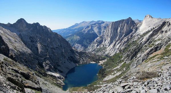
Shortly after 3:30 A.M., I cross Kaweah Gap, and begin my downward journey toward Giant Forest. In the moonlight, I can see that this is a breathtaking granite canyon scattered with many small lakes. The largest of these is Precipice Lake, aptly named. Down, down, down into the canyon I descend, slowed considerably by loose cobbles underfoot. The trail is narrow in many spots, with a sharp dropoff at the very edge of the trail. I peer into the abyss, and shine my headlamp into the depths, but I cannot see the bottom. This is not the place to run. I creep along at a very careful walk. This is the section of trail dubbed "The Golden Staircase." Several miles of this trail was hewn out of solid granite, at considerable expense. Many people mention a short tunnel along this section, but I think the tunnel is the very least of the wonders. This whole section of trail, between Kaweah Gap and Bearpaw Meadow, is simply stunning. And it isn't for the weak-kneed, in either sense of the expression.
Dawn begins to break when I'm about halfway down the canyon. The change is subtle at first, but then I begin to notice that I can see the bottom of the abyss. It is much farther down than I had ever imagined. My legs, thanks to any hard miles, have turned to limp spaghetti by now. But those same miles--and a night without sleep--have numbed my brain as well. I should probably be afraid here, but I simply glance over the edge and acknowledge that I'd better continue to be really careful. One slip, and they'd probably never find the body.
After Bearpaw Meadow, the trail is quite tame. It's almost an anticlimax. But by now, I'm ready to be done. I scamper down the last ten miles of forested trail, into the giant sequoia grove at Crescent Meadow, finishing right at noon. My journey has taken exactly thirty hours. I have arrived earlier than expected, so I catch the shuttle to Lodgepole and eat some lunch.
When I arrive back at Giant Forest, I see our truck parked in the lot. John and I have arranged for this. If we miss each other, he is supposed to stash the key underneath the truck and leave a note saying where he has gone. When I reach the truck, there's no key and no note. I don't know if he has gone up the trail looking for me or gone hiking somewhere else. Exhausted, I curl up on a large flat rock and rest.
After several hours, my dad appears. He was with John, and tells me that John has hiked up the trail looking for me. By now, John thinks I am overdue, and I'm sure he is worried. It's getting dark, and I'm beginning to shiver. My warmer clothes are still dampened with sweat. At least my dad has the key to the truck, so I can get warm. Finally, about 9:00 P.M., I am rested enough to try hiking back up the trail to look for John. I'm beginning to worry a little. I put on my headlamp and begin to trudge back up the hill, periodically shouting John's name and blowing my whistle. No response. After only two miles, I am simply too exhausted to continue. I am beginning to stagger, and cannot negotiate the edge of the cliff safely, so I return to the truck. My dad is still there, but he has a foot injury that prevents him from hiking. There's nothing to do but curl up in a blanket and wait.
About 2:00 A.M. I awake to a flicker of light and hear John's voice. Thank goodness! We each tell our story. Believing that I was still on the trail, John had hiked about five miles up the trail in the afternoon. That is, he had hiked five miles up the trail without carrying a flashlight. As it grew dark, he turned and headed back down, but the forest quickly became pitch-black. He lost the trail for a little while, and crawled on hands and knees, feeling for the trail with his hands. He had his camera along, and the camera had a flash, so he tried to use the flash to get a momentary glimpse of the trail. But the camera battery was dead. Eventually he found the trail again, and made his way back in the dark.
Except for John's little blunder in the forest, I was pleased with my trans-Sierra journey. After doing this route, I wonder why I haven't heard of more people running the High Sierra Trail. Running it non-stop, I saw the Sierra in a way that I couldn't by any other means. I saw the vastness of the mountain wilderness. Every time I venture up into the mountains I vow to return. We're rapidly approaching the first Sierra snowfall, and very soon the high country will be under snow. But I'll be back. Maybe on skis this winter, but certainly I will run the high country next year. I can't stay away.
-- Marcia Rasmussen, 4 Sept. 2007
Before that, Brett Maune ran 18h39m, September 2, 2011.
The previous FKT was Brian Robinson & Peter Bakwin, 24h58m August 19, 2010.
Marcia Rasmussen ran the HST in 30h from Whitney Portal to Crescent Meadow, but not including the summit of Mt Whitney, September 2-3, 2007.
Sarah Thompson has the women's FKT of 23h05m from Whitney Portal to Crescent Meadow & without summitting Whitney, July 10, 2016.
Allen Currano did the HST yo-yo (Crescent Meadow to Mt Whitney & back) in 44h02m, August 13-15, 2016.
The High Sierra Trail runs 49 miles from Crescent Meadow in the Giant Forest area of Sequoia & Kings Canyon National Park to a trail junction with the John Muir Trail at Wallace Creek. From there the HST & JMT are the same trail to the summit of Mt Whitney. Hikers must continue another 11 miles from the summit to reach the trail head at Whitney Portal. So, as a practical matter, the HST is really 72 miles from Crescent Meadow to Whitney Portal. Reading most descriptions of the HST one gets the impression that it technically includes only the 49-mile section west of the JMT. However, the Mt Whitney summit plaque (below) suggests that the HST reaches the summit. Still, there are questions about the eastern endpoint of the trail, as discussed by Marcia Rasmussen below. It seems most complete to consider the HST as running from TH-to-TH (Whitney Portal to Crescent Meadow), and including the summit of Mt Whitney. But, people should just be clear about what they have done, and provide intermediate splits so that times can be compared.
Most hikers travel in the HST in the west-to-east direction, which allows some time for acclimation to the higher terrain to the east. However, the higher altitude of Whitney Portal (8360') vs. Crescent Meadow (6700') argues for speed attempts to be done east-to-west. This is especially true since Mt Whitney, just 11 miles from Whitney Portal, is at an altitude of 14,500 feet, providing for a net loss of nearly 8000 feet from this point to Crescent Meadow. The permit process (below) also makes east-to-west trips more practical.
A note on permits: To do the HST in one push (without camping) one requires only a day-use permit for Mt Whitney. This page describes the procedure for obtaining permits. Basically, you can enter the lottery in February (by mail), or you can show up by 2PM the day before your hike at the Interagency Visitor Center in Lone Pine and try for (by another lottery) a walk-in permit. Walk-in permits are normally available, but definitely not guaranteed. Even if you have a permit reservation from the February lottery you must still pick it up at the Interagency Visitor Center in Lone Pine the day before your trip.
Despite the quality of the route & long history of this trail, speed trips on the HST are rare. Perhaps the 300-mile, 5.5-hour car shuttle for a 72 mile run has something to do with this! Also, the HST is a VERY committing route. Once you drop down off the west side of Whitney the bail outs are extremely long and will deposit you at remote trail heads a LONG way from your car.
At 6:00AM on 2 September 2007 Marcia Rasmussen set out to run the HST in a single push, starting at Whitney Portal. Marcia skipped the 4.8 mile out-and-back from Trail Crest to the summit of Mt Whitney, so technically she did not run the entire HST. She arrived at Crescent Meadow exactly 30 hours later. Her detailed report is below, and speaks beautifully of the love of the mountains that serves as the foundation for many speed trips.
Sarah Thompson reports below running the HST from west to east in 23h05m on July 10, 2016. Like Rasmussen, Thompson did not summit Whitney.
"Long-distance running is really, really, REALLY boring. I honestly had no idea until I ran 70 miles through some of the most beautiful terrain." - Sarah Thompson
The first speed run of the entire HST (including Whitney) of which we are aware was done by Brian Robinson and Peter Bakwin, starting at Whitney Portal at 4:45AM on 19 August 2010. Splits from their 24h58m trip are below. Robinson was unable to train at altitude and had difficulty on Whitney, which cost a lot of energy and left him calorically depleted. The pair soldiered on, but took a wrong turn at around 2AM just 6 miles from Crescent Meadow, adding about 2 hours to their trip. They recorded splits as follows:
Whitney Portal 0h00m
Trail Crest 3h01m
Mt Whitney 3h57m
Trail Crest 4h46m
Wallace Creek (JMT junction) 7h40m
Lower Kern Canyon 10h50m
Kaweah Gap 16h19m
Bearpaw Meadow 19h24m
Crescent Meadow 24h58m
Subsequently, Brett Maune lowered the FKT to 18h39m on Sept. 2, 2011, as reported below. One year later, Leor Pantilat recorded an excellent 15h46m, as reported below, along with Pantilat's usual stunning photos!
Allen Currano reports below doing an HST yo-yo from Crescent Meadow to Whitney and back in 44h02m, August 13-15, 2016. Currano started at Crescent Meadow and reached the summit of Whitney in 20h06m, which appears to be the eastbound FKT for the HST. He spent 20m on the summit, then returned to Crescent Meadow in 23h36m.
Big Terrain on the HST
Here's Marcia's detailed report from the ULTRA List archives:
Sunday of Labor Day weekend is a busy day for the Mt. Whitney Trail. I am shocked to see numerous used poop bags left alongside the trail, as if it were garbage collection day on the mountain. When I stop at Trail Camp to refill my water bottle, the water source there is polluted with chunks of someone's discarded pasta. So, after completing the ninety-some switchbacks shoulder to shoulder with the hordes, I am pleased NOT to accompany them all to the summit. When I turn off alone onto the High Sierra Trail, someone calls out to me that I have made a wrong turn. I grin. In this case, it was most definitely NOT a wrong turn.
I leave Whitney Portal at 6:00 AM with the intention of running the 71-mile High Sierra Trail nonstop. At Sandy Meadow, somewhere around mile 16, I meet a gentleman hefting a large backpack, with a clean white tea towel folded and hung carefully from his chest strap. "Where are you headed?" he asks.
"Giant Forest." I try to sound casual.
"You've got a long way to go." The gentleman appears to think about this a little more. "You've got a REALLY long way to go," he said again, eyeing my tiny day pack curiously. "When do you plan to get there?"
"Tomorrow afternoon." And then, to add a little more credibility, I add, "I run a little."
Another pause.
"Why would you want to do that?" From his expression, I can see that this is a real question. He genuinely wants to know why someone would run quickly through this beautiful country, rather than taking time to savor every step.
I nod. "Well, I've done it the slow way too. Sometimes it's nice to get rid of the heavy backpack. It's a feeling of lightness and freedom, to glide along almost effortlessly though the high country." I explain that if I go nonstop, I'm spared the weight of sleeping gear and a heavy food-storage canister to protect my food from bears while I sleep.
The gentleman appears thoughtful. He looks at my tiny runner's pack, looks at his own heavily-loaded backpack, and looks up at the trail ahead of him, as it switchbacks endlessly up the back side of Mt. Whitney. He nods quietly. I think, for the first time, he understands the beauty of trail running.
"I've got to be going. Have a nice time on Mt. Whitney." I turn and pad across Sandy Meadow. A soft breeze ripples through my hair, and I suddenly feel I haven't a care in the world.
The gentleman turns and starts up the trail in the other direction. It may be my imagination, but I think I hear a soft sigh escape his lips.
Afternoon approaches, and dark clouds begin to gather over the high peaks. I reach Wallace Creek, where the High Sierra Trail and the John Muir trail diverge. I follow the High Sierra Trail along Wallace Creek as it dives sharply downhill, though a rocky canyon. The creek bubbles and gurgles and cascades noisily toward the Kern River canyon below. Again, I feel the breeze in my hair, but this time it is cooler, and it accompanied by the rumbling of thunder. It's time to get off the ridge. I pick up my pace slightly, hoping to reach the relative safety of the Kern Canyon before the storm breaks.
The upper Kern Canyon is a jungle of bright green Manzanita brush, with twisted red trunks-a bright contrast to the white granite walls of the canyon. Occasional thickets of aspen rustle in the breeze of the oncoming storm. The wind carries a shower of aspen leaves, just barely tinged with gold. I feel a sprinkle of rain, driven by the wind, but in a few minutes, the storm dies down. Not far down the trail I meet two middle-aged women, who stop and ask directions. They are wearing rain gear, and they very obviously have just been on the receiving end of the downpour I missed. We stop and chat for a few minutes. It is evening and we are twenty-five miles from the nearest road. Eyeing my tiny runner's pack, the women begin to ask questions. I explain that I'm doing a nonstop run of the High Sierra Trail. They reply that they're taking several days to cover the same ground. I laugh and explain that they are traveling in the uphill direction. When you travel this trail east to west, it's mostly downhill, and much faster. But they were not convinced. I'm sure they went home and told their friends they met an elite distance runner out in the mountains. If only they knew.
Nine miles of trail follow the Kern River through its canyon. As the river drops in elevation, manzanita and aspen give way to thick pine forest. Darkness begins to fall in the forest. In the periphery, my tired eyes begin to catch movement. I look and there's nothing there. I remember a dream I had recently, in which the glowing green eyes of a mountain lion followed me in the darkness. My footsteps quicken. Suddenly there's a flash of tawny color, crashing through the brush. My heart leaps to my throat. Oh, it's only a deer.
I stop at a hot spring along the riverbank and take a few moments to bathe. The steaming hot water soothes my tired muscles and dissolves the salt crust from my hair. I celebrate the moment with a piece of chocolate I've been saving. I could stay here for a very long time, but I still have many miles to cover before I sleep. I am not quite at the halfway point of my run. I force myself out of the hot spring into the chilly evening air, clean and refreshed. I am ready to tackle the switchbacks, as the trail climbs the canyon wall and ascends to the Chagoopa Plateau.
Tyger, tyger, burning bright
In the forests of the night.
The poetry of William Blake strolls across my consciousness as I pass through mile after mile of pitch-black forest. There are no tigers here, and the only thing burning bright is the light of my headlamp. I am comfortable alone in the forest at night. There is very little to be afraid of in these mountains. But, yes, things do occasionally happen to people who wander far off into the mountains at night, and those thoughts do not escape me entirely. I remember John's last words to me, as he kissed me goodbye early that morning. "Have fun. Don't get eaten."
Finally, the moon begins to rise, and the dark forest is transformed into a moonlit wonderland. High peaks have appeared on my left, and I can see Sawtooth Peak in the distance, bathed in moonlight. On and on, mile after mile, the pine forest turns to scrub fir and then high alpine meadow dotted with lakes. The moon is overhead now, and I find that I can turn off my headlamp and see quite well. A babbling stream runs through the meadow, and nearby waterfalls reflect the moonlight so that they appear to shimmer and glow. I stop for a long moment and take a mental snapshot of the scene. What a wonder it is to be alone in the high mountains at night. To move on and on through the night, through miles and miles of this high country, is nothing less than magical.
As I climb higher and higher toward Kaweah Gap, the soft meadow becomes strewn with boulders. The trail becomes rocky, and it's impossible to move without the clatter of large rocks underfoot. The terrain here is not steep, so I can manage a slow shuffle-which makes a terrible racket. It is 3:00 A.M., and, as far as I know, I am the only human within miles and miles. Suddenly two bright lights appear about fifty feet behind me. And then it dawns on me what has happened. Apparently these two backpackers had pitched their tent very close to the trail. In the darkness, the tent looked just like one of the rocks. The hikers are awakened by the clatter of a large creature running almost overtop of their tent. They stumble, bleary-eyed, out of the tent and shine their lights all around, but see nothing. I am standing a few yards away, out of range of their lights, giggling softly to myself. If you hear a story about some backpackers whose tent was nearly run over by Bigfoot himself, now you know the real story.
Shortly after 3:30 A.M., I cross Kaweah Gap, and begin my downward journey toward Giant Forest. In the moonlight, I can see that this is a breathtaking granite canyon scattered with many small lakes. The largest of these is Precipice Lake, aptly named. Down, down, down into the canyon I descend, slowed considerably by loose cobbles underfoot. The trail is narrow in many spots, with a sharp dropoff at the very edge of the trail. I peer into the abyss, and shine my headlamp into the depths, but I cannot see the bottom. This is not the place to run. I creep along at a very careful walk. This is the section of trail dubbed "The Golden Staircase." Several miles of this trail was hewn out of solid granite, at considerable expense. Many people mention a short tunnel along this section, but I think the tunnel is the very least of the wonders. This whole section of trail, between Kaweah Gap and Bearpaw Meadow, is simply stunning. And it isn't for the weak-kneed, in either sense of the expression.
Dawn begins to break when I'm about halfway down the canyon. The change is subtle at first, but then I begin to notice that I can see the bottom of the abyss. It is much farther down than I had ever imagined. My legs, thanks to any hard miles, have turned to limp spaghetti by now. But those same miles--and a night without sleep--have numbed my brain as well. I should probably be afraid here, but I simply glance over the edge and acknowledge that I'd better continue to be really careful. One slip, and they'd probably never find the body.
After Bearpaw Meadow, the trail is quite tame. It's almost an anticlimax. But by now, I'm ready to be done. I scamper down the last ten miles of forested trail, into the giant sequoia grove at Crescent Meadow, finishing right at noon. My journey has taken exactly thirty hours. I have arrived earlier than expected, so I catch the shuttle to Lodgepole and eat some lunch.
When I arrive back at Giant Forest, I see our truck parked in the lot. John and I have arranged for this. If we miss each other, he is supposed to stash the key underneath the truck and leave a note saying where he has gone. When I reach the truck, there's no key and no note. I don't know if he has gone up the trail looking for me or gone hiking somewhere else. Exhausted, I curl up on a large flat rock and rest.
After several hours, my dad appears. He was with John, and tells me that John has hiked up the trail looking for me. By now, John thinks I am overdue, and I'm sure he is worried. It's getting dark, and I'm beginning to shiver. My warmer clothes are still dampened with sweat. At least my dad has the key to the truck, so I can get warm. Finally, about 9:00 P.M., I am rested enough to try hiking back up the trail to look for John. I'm beginning to worry a little. I put on my headlamp and begin to trudge back up the hill, periodically shouting John's name and blowing my whistle. No response. After only two miles, I am simply too exhausted to continue. I am beginning to stagger, and cannot negotiate the edge of the cliff safely, so I return to the truck. My dad is still there, but he has a foot injury that prevents him from hiking. There's nothing to do but curl up in a blanket and wait.
About 2:00 A.M. I awake to a flicker of light and hear John's voice. Thank goodness! We each tell our story. Believing that I was still on the trail, John had hiked about five miles up the trail in the afternoon. That is, he had hiked five miles up the trail without carrying a flashlight. As it grew dark, he turned and headed back down, but the forest quickly became pitch-black. He lost the trail for a little while, and crawled on hands and knees, feeling for the trail with his hands. He had his camera along, and the camera had a flash, so he tried to use the flash to get a momentary glimpse of the trail. But the camera battery was dead. Eventually he found the trail again, and made his way back in the dark.
Except for John's little blunder in the forest, I was pleased with my trans-Sierra journey. After doing this route, I wonder why I haven't heard of more people running the High Sierra Trail. Running it non-stop, I saw the Sierra in a way that I couldn't by any other means. I saw the vastness of the mountain wilderness. Every time I venture up into the mountains I vow to return. We're rapidly approaching the first Sierra snowfall, and very soon the high country will be under snow. But I'll be back. Maybe on skis this winter, but certainly I will run the high country next year. I can't stay away.
-- Marcia Rasmussen, 4 Sept. 2007